Gay City State Park – Hebron CT

Sometimes I get tired of finding new locations or I just lack inspiration. It’s at these times I like to hand the torch over to my travel companions and tell them to pick a place. I’m always happy to drive and the surprise of these adventures ticks off my ever expanding need for novelty.

On this day the choice was to go to Gay City State Park – a location in Connecticut that came up as a FaceBook suggestion to my travel companion. Let’s go!

Gay City State Park was easy enough to get to but they were taking trees down at the entrance when we drove up so we had to wait for them to move it out of the way. From there there was a really large parking lot for a park. This place was sort of huge. We followed several other people who were already out walking their dogs. They all made their way to a shut off road that goes straight into the center of the park. It had a toll booth and all. To the side there was a campground and signs were up for swimming holes, By Scouts, and various other activities. I am glad I didn’t come to this place during the summer season. It looks like it’d be flooded with children escaping the city. In this sense it was a lot like Rangeley, just bigger. What were we here to see again?

“The remnants of a ghost town.”

OK then! We took what looked like the main trail and began to hike into the woods. It was a pretty easy trail, a few mild inclines here and there but nothing too bad. Since it was gray and threatening to rain on this day the bare trees took on a bit of a foreboding appearance. When we came to a fork in the trail we just started walking down random branches of it. I have no idea how my travel companion can find his way back after doing this – I never could. One wrong turn and I’m screwed. We did eventually come across the foundation of an old house aside the trail. Ferns grew out of the walls and gave it a bit of a Secret Garden kind of feeling. Still, we’re a both a bit jaded at this point having seen quite a few ruins, we had to ask was this it? We continued to hike. Luckily it wasn’t raining yet and the temperature was perfect for a brisk walk through the leaf litter.

Eventually we made our way back to the main path which was supposed to have a ruined mill on it and sure enough it wasn’t long before we found it. I’ve seen lots of ruined and abandoned mills but this one was old! Only part of the foundation remained (after the structure burned down on three separate occasions) and it was not messing around. I’m pretty sure it’ll still be there in another 100 years! It made me wonder what it looked like when it was fresh and new and how many people worked here. I took some time wandering around taking somewhat artsy photos. It was worth the trip!

There’s rumors of a few weird terribly New England-y murders happening here back in the day when the town was thriving. Some people pay for permits to camp so they can ghost hunt at night. We did not… for we had other places to go!

We wandered back to the car to explore a second destination. There was supposed to be an abandoned missile silo from the 1950’s hidden just eight miles away. However the GPS just brought up to a random neighborhood and there was no indication there was a trail, an appropriate place to park, or anything else you might think would go with such a destination. We didn’t even bother getting out of the car. Instead we headed to our third and final destination of the day – the Ballard Institute and Museum of Puppetry.

Glen Farm Trail/Abandoned Ice House – Portsmouth RI

The East Coast got a little bit of a shake-up the other day as a tropical storm hit. Some of us even had tornado warnings. I was in Rhode Island and the damage here wasn’t quite so fierce. There was a lot of wind and then maybe 10 minutes of downpouring rain and then…. massive power outages. Which was the perfect motivation to go back outside on another little side quest. To the Glen Farm Trail!

I’ve never heard of the Glen Farm Trail but seeing as I was being offered to check it out I couldn’t really say no. I have been to a bunch of little trails in populous areas and although the city parks are adorable and well maintained they rarely have much interesting in them. This trail however had a lot of character.

For one going directly after a rain storm made for some interesting lighting that added just the right amount of whimsy. Secondly it cut through a slate forest – this region (and Boston) are where the slate was quarried that would later be made into those beautiful grave stones I am always admiring. So it was interesting to see the rock in it’s natural habitat as it were but it was better than that.

Here I found a bunch of No Trespassing signs and a fence which had been unceremoniously toppled.

“Some guy bought the surrounding property and is being a dick about it. The locals said ‘Fuck this fence’ and now we just walk over it.”

I appreciated the community spirit of mass rebellion. And I can see why they’d be so insistent. There was something really charming about this little forest and the weird slate walls that popped up here and there as well as the small slate bridges. But that wasn’t what we were here for. That would be an old abandoned ice house just sitting here in the woods looking adorable and sad all at the same time.

Now if you don’t know what an ice house is I’ll give you a brief run down. Back before electricity and refrigerators the only way you could get ice would to harvest it in the winter from lakes and rivers and ship it in insulated containers wherever it needed to go. The old “ice boxes” that predated our modern fridges ran off a block of ice replaced every day or so. It was a rich person’s luxury and a whole industry here in the North. A whole industry that died a rather sudden death with the invention of electricity and refrigeration.

I was delighted to find we could skip across the little river and enter this archaic structure. Apparently others had come before and just like the last place I went it was covered in graffiti which is always a source of entertainment for me. Good graffiti artists can do some really impressive work but bad graffiti artists… well they’re just hilarious. And frequently very confusing! But it’s all good fun to try and puzzle out.

After this we found a tiny ocean beach at the end of another of the trails. It’s been a long time since I have been oceanside. The smell of the salt and the lapping of the waves enlivened my spirit. We sat and watched someone flying a kite in the far distance and enjoyed the moment. It was a nice way to keep cool and calm.

I’d suggest this trail to anyone in the area as it seems to have just a little magic in it.

The Ice House:

The Little Beach:

The Trail Itself:

“The Bells” Abandoned Stables Newport RI

“The Bells” were on my list of things to check out for quite a while, long before I knew a local who wanted me to go see them. That being said it was perfect going with someone who actually knew about them.

I had learned about them from Atlas Obscura and I couldn’t help but feel like the ruined and possibly haunted stables of a once grand estate sounded like a terribly fun place to check out. It’s surrounded by public land and little trails so after parking we made our way through a field to the trail which led directly to the stables with very little walking. The whimsy was overwhelming from this angle. To every side there were trees clawing their way into the structure and lush greenery creating an oddly tropical looking trail by it. It was magnificent but we were just starting.

Down one of the paths nearby, and not very much of a walk at all, there was a tower also on the grounds which you could climb to see an even more stunning view of the stables from above. From here the stables had the feel of a Gothic horror – just a castle slowly crumbling back into nature.

Afterwards we came back down and looped back past the structure. The view from the ground was a lot less dramatic but still whimsical in it’s decay. It was surrounded on all sides by a fence. Even though I am not usually one for trespassing curiosity killed the cat with this one and I too waited until no one was looking to follow aforementioned local into this enticing mystery.

Here I found a great deal of graffiti from ceiling to floor covering every inch of space. There were indeed stalls inside for once spoiled horses, including two box stalls at the end which makes me think there may have even been the occasional foal born here – though don’t quote me on that.

What I do know is that the stables are the only thing left from what was once a grand and majestic 1876 estate that fell into disrepair before burning down in 1960. While I enjoyed reading the graffiti I was regaled with tales of ghost horses galloping in the mist that surrounds the property at night. It was a delightful story in a gorgeous setting. Even the parking lot was sort of amazing – a nice view of the coast with a lighthouse standing stoically in the distance and waves anxiously lapping the shore.

Being such a gorgeous day a lot of people were out with their dogs and children but almost everyone was masked and courteous and this was not as populated with people as some of the other trails I have ventured this year. All and all it was a wonderful little adventure and well worth poking around a little bit.

I took A TON of photos which I will display below in sections. First up is The Stables:

Next up is the tower/view of the stables from above:

Guaco Pond – Fishing and Kayac Launch Athol MA

From the West Cemetery I continued on and I can’t believe it but I actually wandered so far into the middle of nowhere that I can’t really pinpoint where I was! There isn’t even a Google street view! And since I didn’t have my own GPS today I couldn’t push the “Where am I?” button. I tried to use my cell phone for this but I failed again because there was no internet to be found. I was in No Man’s Land. It’s not surprising. This place was so scarcely populated that I only saw maybe two houses on the entire road. This was the beginning of my tour though a bunch of dirt roads even further into the middle of nowhere.

I turned onto Monson Turnpike Road from West Street and it was just a loooong dirt road surrounded by trees. It was like going back in time. Driving a Prius down these narrow and sometimes flooded out “primitive roads” is not the best idea but I did it anyway. There were signs up saying these roads were closed from November through April. That’s how I knew I was somewhere cool. You know, the kind of remote regions where only the odd camp sits and where hunters and hikers long to go.

Soon I started seeing signs, “wildlife management area” which I thought might mean a trail or two could be found. I was not so fortunate but I did find a turn off to what I believe was Guaco Pond where there was a tiny boat launch and signs saying fishing and hunting were permitted. I don’t hunt or fish but this place was like a little slice of heaven. I parked the car and wandered towards the water to take a couple photos. I got the feeling I was in real proper wilderness. The ground beneath my feet started to leap towards the water – the shore was full of frogs. Here too were so many dragon flies and wild flowers. A few rocks sprawled out over the water allowing for the absolute perfect spot to just sit and enjoy nature. In the water below I could see fish dancing about – some even looked like the fat and edible varieties, though they were still small.

I stayed for quite a while in this one spot just enjoying the scene, listening to the water gush in from the stream that traveled under the road. It was so remote and peaceful and yet so terribly alive with frogs, fish, dragonflies, beavers, and birds. I can only imagine it would have been the perfect spot to actually go fishing or to take a kayak out. Absolutely stunning. I even found a patch of wild raspberries growing in the sun. The whole time I was there only two cars passed by, obviously locals because they sped by on a road I didn’t dare go above 15 miles an hour (with a Prius anyway.) This was a breath taking find and I was feeling optimistic when I headed back to the car to find another little gem. It would be another cemetery – The Northwest Cemetery in Petersham.

Lower Purgatory Falls – Lyndeborough NH

Just when I feel like I know where everything is and there’s no new places to explore I get another giggle from the Universe. Lyndeborough is only thirty minutes from where I live and I had no idea this town even existed. I have never heard of it which is a shame because apparently that’s where the devil makes beans. Or something. I may have gotten that one a bit wrong… but what I do know is that Lyndeborough is one of many purgatories you’ll find scattered through our deliciously Puritanical New England. This time it comes in the form of waterfalls.

I was told by a few different people it was somewhere I needed to check out so I looked it up vaguely online for an address. There were numerous people who claimed the parking lot was hidden, that it was near impossible to find, and that the GPS will only lead you to a sign across town reading:

OK, so let me explain the sign. It’s placed on Purgatory Falls Road which being the clever thing I am I figured was the home of Purgatory Falls. So I let my GPS take me there because it was being a total jerk today and wouldn’t acknowledge that not only Purgatory Road was a real place but also the entire town of Lyndeborough. SIGH. Now here’s the trick. Purgatory Falls Road is NOT correct but plain old Purgatory Road is. And the parking lot is indeed really frelling easy to miss. The signs out front are worn right off the trees and it doesn’t even look like a trail head. I had to drive in and find a single 8 by 11 sign hanging above a trash can that let me know that yes, I found the right place (by following good old fashioned print directions.) But I’ve made it easier for you. While I was in the parking lot I took a snap of my GPS coordinates which your GPS should not fuck up!

Alright, now that we have that cleared up… I was only one of three cars there when I arrived. When I entered the woods I was greeted by the usual path although there wasn’t a damn marker anywhere and the trail kept having other little partial trails jutting off it. Sooooo I was already hesitant but I did manage to end up at Lower Purgatory Falls which was perhaps a quarter of a mile in. I was lucky to show up early enough that no one was here. I had the whole waterfall to myself. It’s apparently a popular swimming hole with a nice area below and above the falls to take a nice ice cold dip. There were missing items of clothing and random trash scattered through the whole area. I had done a very shitty amount of research before I left and knew that this was Lower Purgatory Falls but that there is also an Upper Purgatory Falls somewhere. Stupidly I thought this was a loop trail. And I was feeling a bit brazen because I saw the first trail markers at the falls. I’m already in the woods why not? I took the yellow trail, whatever that is, but it wasn’t long before I realized every goddamn trail was marked with yellow markers. They all led into each other sure but… whew, that was confusing.

It was a hot out today and I didn’t really feel like dying out here so I tried to stay near the riverbank figuring it was likely the river attached to the other falls and definitely was the river attached to the Lower Falls should I need to get back to the car. It was a pretty little hike with lots of little inlets and river scenes. I was enjoying myself. But then I had to turn away from the river and that made me get a bit fidgety. Up until then I’d only seen two other hikers who I thought were an army. Christ were they a loud bunch. I was shocked to find they were a young couple and not a circus troop of small children (the only kind of people I’d expect so much noise from!) From here the trail was… sketchily marked, at times getting pretty overgrown and hairy and at two places surrounded by “NO TRESPASSING!” and “Security cameras are on!” signs. Not very welcoming. Those were attached to the properties of two mansions and I just can’t help but wonder what is wrong with those people. You bought a house almost built directly on a popular public trail did you not expect people to be wandering by? Idjits. Oh what I’d do to live on a house attached to such a nice hiking trail! I’d be HAPPY.

And I kept walking. And walking. And walking. Deeper into the woods. The trail markers are now mostly yellow with a few white ones mixed in to keep me guessing and offshoot trails are appearing with orange and blue markers. Finally I was back at the river bank. I immediately looked for a spot to stop and rest. Heat exhaustion was starting to make my head hurt. And then I saw the PERFECT little spot. A rock stretched out over the water and allowed for a nice semi-secluded spot to sit so I crawled out there, lobbed off my shoes, and splashed in that COLD COLD water like a small child. It was shaded and the water was so cold it actually hurt to put my feet in it but I was desperate and it did make me immediately feel better. I dithered about there for a while before passing hikers make me feel a bit self conscious so I moved on.

The trail ahead was not the “easy” beginner trail I was told it’d be online. Jagged and often slippery roots, steep hills, and terrifying cliffs dotted the entire route. My knees were screaming bloody murder at me. And now my head and stomach were kicking in. Heat. And then I came to a clearly marked trail junction that pointed to whence I came “Lower Falls” and another path “Purgatory Brook Trail” which I think leads to the other falls. So I kept going even though by now I was toast. I’d WAY overdone it. I needed to be at the car not 4 or 5 miles into the woods. I still kept going before reaching a bridge that both had trail markings and yet another Private Property/No Trespassing sign. I sat down, pulled out my phone, turned the mobile data on, and started to figure this out. First I tried “Where am I?” which resulted in a map…. of literally nothing no matter how much I zoomed out. Fuck. Now I’ve done it. I’m in no man’s land. Then I tried looking up where the falls were on the trail. One source said 5.1 miles apart, another said the whole trail was 15 miles. All said they started in one parking lot and ended in another. NOT A LOOP. And I didn’t have any kind soul to pick me up at parking lot #2 because I was too stupid to plan this out better.

I turned back and started marching. It seemed like forever before I found that rock plank over the river again and when I did I stopped and dunked myself. In fact I wandered around a bit splashing water over myself as much as I could. A hiker sneaked by me as I was probably looking like a lunatic prospecting for gold. I’d seen very few hikers out today but ALL of them caught me doing or saying something nutty. One caught me muttering, “Yellow trail my ass! These markers are shit!” A second caught me cursing again at myself when I twisted my ankle going down a hill, “Fucking no! I am NOT breaking my goddamn ankle out in the goddamn woods!” Luckily no one came upon me with my ass in the air taking a macro photo of an adorable mushroom I found on a ground but that is usually when people do pass… This has all taught me 1) I curse a profound amount and 2) I’m probably pretty embarrassing to be around.

When I gathered myself up from the river I decided to dunk my socks in the water so I’d at least have something cold and wet around my ankles keeping me sorted as I made my way back. Another egregious trip back. This time when the trail weaved away from the water I sort of freaked a little bit because in this direction it was marked even worse. Would I ever get back to the car?! Every now and then I’d notice something to keep me somewhat distracted like a half-made fairy house made of birch bark or a grackle. We have grackles in New England?! WHY IS IT MOCKING ME?!

Eventually I heard my phone ringing. My mother had noticed hours after taking her car that I was missing. I’d arrived at 10:30. It was 3PM before I finally found my way to the parking lot. This time the waterfalls themselves were filled with people but I was less than thrilled to walk from the falls back to my car in a rat’s nest of unmarked trails and half trails. Just keep walking. Just keep walking.

I made it. What a glorious sight the car was. It was however hotter than hell when I opened it up and as it burped out that 140 degree stale air I was dooooone. I’m home now. Already in pain. Going to be paying for this one for days to come! But although I know I will be in a coma for the next couple of days I am still happy I went. And heeeeey, maybe I can drive to the Upper Falls parking lot and see the upper falls and the devil’s bean pot from there. Then I can say I did the whole trail and stop feeling like such a hiking wuss.

Willard Pond – Antrim NH

So after spending a nice bit of time at Sarah’s Hat Boxes I took my mother out on part two of today’s adventure: Willard Pond. It wasn’t that far away and was super easy to get to. I’d heard about Willard Pond many times but hadn’t made it out there. I was told it was however beautiful – it’s a small protected lake in Antrim NH which has no houses on its shores and does not allow motors of any kind on the trails or in the water, basically a preserve.

The entrance to the lake is located at the end of a long dirt road that drags you pretty far out into the middle of the woods before it just ends at a dirt parking lot. It was here that I found a portapotty which I thought was a bit odd until I realized it appeared to be a popular swimming hole or if I am being more accurate a series of swimming holes which would explain the squealing delighted child running towards the parking lot – towel flapping in the wind until he lost it, a gaggle of women all giggling over the little scene, a series of other small children taking no notice.

We passed two trail heads before reaching the lake itself and yes, it was beautiful. Today was a gorgeous day out, not too hot, not too humid, and there was a most refreshing breeze coming off the blue-blue water. I took a couple snaps of the swimming hole before deciding to check out the trail to the right which I figured must go around the whole pond. It went up a small hill where a nice rock outcropping was before leading us through a wild blueberry patch and to small dam. There was no bridge across but the two people ahead of us just walked right over it, splashing in an inch of water. I figured I’d try going across with my shoes on. That probably wasn’t the wisest idea… As the trail went on we discovered a series of smaller more private swimming holes, many of them occupied by small groups of people. As we hiked deeper into the woods the trail got increasingly hairy. Personally, if I were alone, I would have kept trucking right through it until I couldn’t anymore. My mother on the other hand said something about not getting her somewhere where I couldn’t get her out. I sighed, she’s probably right, and so we headed back. I will likely be back to check out the two named trails between the parking lot and pond.

I took a long winding nonsensical route home and passed a bunch of other things that I am going to put on my list to check out later – everything from other quirky local businesses to hiking trails and farms. Mother wasn’t as keen on going 4 wheeling with the RAV as I was and twice yelled at me to not listen to the GPS and just stay on main roads. Her sense of adventure isn’t as deep as mine, clearly. I did however pull over to read a random historical marker in Stoddard – I guess the town used to be known for glass. Who knew!

This area was so sweet and rich in things to see and do that I know I will be back soon.

Bridge on Cross Road – Sharon NH

So I realize with the chaos of my current life and my tedious health I haven’t been able to go any gorgeous faraway destinations but sometimes I can find immense beauty practically in my back yard. When I had to run some errands in Peterborough I decided to take a long meandering route home and of course this meant ending up in Sharon NH for no reason whatsoever. I wanted to spend some time riverside so I parked aside a bridge I chose at random that happened to have a place to pull over and park. According to my GPS I was at “25 cross street.” I took a photo of the coordinates if that’s not good enough.

Initially I was just going to take one quick snap of the river from the bridge, maybe a little video, but when I saw a path going down to the water I grew curious and decided to see what was down there. As it turns out there was a delightful little scene. There was of course the customary graffiti under the bridge, a suspicious lack of a troll, and of course a beautiful river scene. I couldn’t tell for sure but this slow moving river seemed to have a few somewhat deep parts and I got the sense this might be a swimming hole for someone. It was certainly hot enough to enjoy such a spot but of course I did not have a swimsuit on me so I had to linger mournfully along the banks. Just kidding. I sat down on some rocks and just enjoyed the sound of the river gushing by me as it echoed under the bridge and as I did so I started to notice all sorts of tiny wonders. There were two incredibly chill frogs I took a shoe selfie with, a starter swarm of of newts just doing their little newty thing, a school of minnows so small I could barely see them, lots of water skaters, and a bubble popping at the surface every few minutes suggesting a turtle was somewhere in the weeds. I was so relaxed I stayed there just observing for probably forty-five minutes – even taking two short films, one of the water on one side and one of the little newts on the other. In that whole time only three cars passed by. This was a wonderful little detour and I hope to go on a proper road trip very soon!

Markey’s Seafood – Portsmouth NH

A few days ago a friend invited me to meet him at the Deerfield Fair. I said sure, I could use a day out, and we planned to meet each other at noon. Sounds good! Until I almost got to the exit into Deerfield, there were cars lined up for a mile in the break down lane. Oh shit… So I swung aside with them and twenty minutes later I found myself in Deerfield but just barely. I was five and a half miles from the destination and it was complete gridlock. Since I was at a standstill anyway I texted my friend who then called me and decided to come pick me up at the used car place I happened to be slinking by. I didn’t know why…. but I guess he and his friend were out on their motorcycles earlier and they wanted to come pick me up, drop off the cycles and my car at this other guy’s house and wander to the fair together as a group…. This is highly unusual for me. I don’t do vehicle hopping and I’m a shit passenger besides but seeing the traffic it just made sense to go as a group and use only one parking space.

My friend’s friend was an older guy who had clearly spent all of his youth living hard and hoping to die young. I hate seeing people like that old… their bodies completely spent, creaking at every joint, seemingly miserable at their lack of mobility… SIGH. But still! What he couldn’t do walking he sure made up for in driving. Ever wonder what it’s like to drive with Hunter S Thompson? AHHHHH HOLY ASS CRACKERS CHRIST! SLOW DOWN! A DEAD MAN’S CURVE! OH MY FUCKING GOD ANOTHER ONE! I imagine it would be a little like that. Also I want to take this moment to apologize to any passengers who may have been in my car while I was driving in a similarly terrifying manner. Know that I love each and every one of you and it’s out of my system now. Sorry.

We went the back roads and immediately hit gridlock again. It was a GORGEOUS day out there. This guy said he’d never seen the traffic this bad, that the Deerfield Fair isn’t usually that crowded, and he hemmed and hawed about being stuck…. for about and hour…. before my friend asked if I was hungry.

“Always!”

“You’re not allergic to seafood are you?”

“Only one way to find out!” Crickets. OK OK, I’ll add anaphylactic shock to the list of things I shouldn’t joke about. Here I thought I was cool because earlier I said the cure to something was “a shot through the head” which elicited shock, horror, and a nervous laugh. I’ve been a bit lippy lately but regret nothing.

To make a long story short we turned around and drove to Portsmouth, probably another 45 minutes or hour away, where I took a few lovely snaps of sea gulls and learned that lobsters have compound eyes. Ah, the things you learn when your food is staring at you! But really, we got some sort of sale and it was 4 lobsters for $32. They also got a combo plate to share between us filled with fried marine miscellany. I think there were steamers, scallops, and fries. And you know what I also learned? That fresh seafood, no matter the shape, all tastes the same when it’s fresh – like nothing. It’s really a texture thing or perhaps a “I need an excuse to eat tartar sauce” thing. Either way I am not complaining! And I was STUFFED TO THE GILLS. This place was really nice as it had a porch outside right on the ocean you could watch or feed the sea gulls from. It was quite relaxing! And here’s a few snaps of boats and seas shore when we parked down the street to check out their beach.

Another hour to my car…. an hour and a half from there home… and I am bushed! And ready for another adventure next weekend! Dun dun dun!


A Quick Winter Update and a Reminder Spring is Coming!

So I admit I didn’t get out much this winter but I still have been busy figuring out what to do with spring once it gets here. I have scheduled myself to visit more ruins, castles, haunted places, light houses, quirky one-of-a-kind mom and pop shops, perhaps a few farms, as well as more nature trails and museums. Who knows, I might even indulge in another passion – food! And to add to the excitement I am expanding to my repertoire of photos and writing with my very first video! I am hoping future videos will include interviews with more interesting local personalities, or at least with more subject matter than just me blathering on! ENJOY!

If you are enjoying Catching Marbles please consider donating to my limited gas money fund so I can continue going on and sharing my adventures with you!


Acadia National Park – Bar Harbor Maine


2017-10-1621_17_30_previewAcadia is one of my favorite places to go. The park is enormous and has something to offer everyone. It has hiking trails of all levels and capabilities for the athletic among us but it also has a variety of stunning views you can either see directly out your car window or very easily access. If that’s not enough to tempt you there’s also a number of beaches both rocky and sandy and a few other attractions that lure the curious.

2017-10-1622_26_53_preview
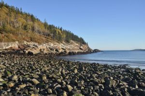
I have been to Acadia two or three times already, always off season, and I didn’t pay anything to get in because of this, but I guess I was either too early this year or they changed their policy. Some of the park remained free – like the drive up Cadillac Mountain, but by the time I got close to Thunderhole I approached a toll gate and had to fork over $25 for a week’s pass. That’s OK though, it was worth it.

2017-10-1622_35_23_preview
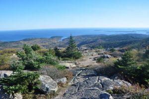
This visit was a short one as I was busy socializing for most fo the day and only arrived at 2PM but I still packed a lot into a few hours! I especially wanted to drive to the summit of Cadillac Mountain to get a few nice foliage photos and enjoy the fresh mountain air. I was shocked how many people were here! But I guess when the weather is a freakish 70-some-odd degrees people are more likely to come out and enjoy nature at its finest. I stopped at several points to take a few snaps and enjoyed the summit as well as the Overlook at Blue Hill the most as far as the mountain went. I ended up shuffling out onto the bare rocks at the summit and enjoyed a bit of time just soaking in the view – which included all the colorful trees I could wish for, a delightful pond, a few islands off the coast, and unseasonably blue skies. It was hard not to stay here forever. Unlike many parks Acadia is open 24/7 all year long…. Obviously this means I must return once more… at night. The view must be amazing then! I wonder if you can hear loons or if wolves exist in the park…

22520125_10212711999409188_2363148457676078679_o
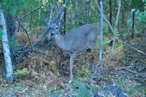
Anyway, that flight of fancy erased from my mind I continued onwards, driving back down the mountain. On my way I had to stop the car to let a deer pass and took a shot out my car window of a second that was staring at me from a few feet away. I got one good snap before another car barreled by in the travel lane scaring them both off.

2017-10-1622_54_06_preview 
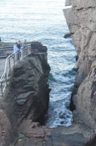
I wanted to see Thunderhole – which is this rock formation at the coast that makes a thunderous noise when the waves from the ocean rush through it. I have been told about it for years from all sorts of relatives ad friends and had yet to check it out… but first I passed Sand Beach, the main sandy beach in the park, and had to get out to amble for a bit. It was low tide. I had never been here during low tide. I must say all the exposed rocks gave it extra character! There wasn’t too many people there at this time of day, or year, certainly no polar bear swimming club to be seen, but there were a few families playing with nerf balls and kites. I’m surprised there weren’t any dogs – as they are allowed in the park.

After Sand Beach I came across something called Otter Point. Apparently Maine has sea otters. There were probably fifteen photographers here, all piled up in different points just waiting around.

“What going on here?”

“Otters.” I giggled, winking at a strange woman who was laughing with me. “They must be waiting for otters! I don’t see any, do you?”

“No…….”

2017-10-1623_13_33_preview
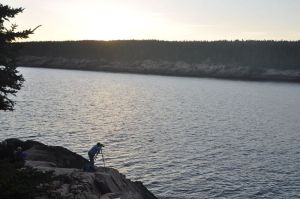
Truth be told these people were probably all here to take advantage of the sunset which was closing in soon. It was a good vantage point for that – though not the best conditions today. It was a bit gray out.

After this I FINALLY found Thunderhole! I parked at the  gift shop, which was afforded no electricity of any kind, and made my way towards the crowd across the street. Here there were railings out onto the rocks so I scrambled down, wondering if I would hear anything at low tide. As it turns out the rocks were making a little noise, not much, but enough to placate me. I took a short video. The day after this my great uncle told me there’s a louder more impressive Thunderhole somewhere else nearby that doesn’t have railings. Apparently several tourists a year get swept out to sea trying to find it. This didn’t deter me. Now I want to go back and find it!

Thunderhole was pretty neat but there was still the tiniest bit of daylight left so I was off to see what else I could see. I ended up at a small unmarked beach that was littered with shells, piles of seaweed, and a bunch of tiny tide pools that were alive with barnacles, snails, shrimp, and probably a number of other little sea bugs. There were two people here, a woman scouring the dry sands at the top of the beach and a man staring intently into the tide pools. I wondered what they were searching for so I asked the woman who was close to me. She was picking up tiny pieces of sea glass to make a novelty travel vial out of. She said being a national park you’re not supposed to take rocks or shells or anything natural so she decided sea glass would be best. I felt no remorse for the three tiny rocks in my pocket – one brilliantly orange, one dark red, one green. I made no mention of the two little shells in the other pocket. They were two amongst millions. I felt no guilt about kidnapping them whatsoever. Besides I am pretty sure the dude was searching for something besides sea glass. Was he a rock hound? Or searching for clams? I’ll never know because he was way too far off to ask. By now the sun had gone down to the point that scouring the beach or looking for other overlooks was pretty pointless so I headed home. It was however a gorgeous day and I had a whole lot of fun.

<strong> If you are enjoying Catching Marbles please consider adding a dollar or two to my limited gas money fund so I can continue going on adventures and sharing them with you! Thank you!


Proudly powered by WordPress | Theme: Baskerville 2 by Anders Noren.

Up ↑